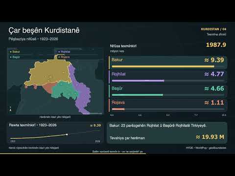
Berawirda nifûsa Bakur, Rojhilat, Başûr û Rojava li herêmên hilbijartî, ji 1923 heta 2026. Hejmar hemû niştecihan, Kurd û ne-Kurd, dihewînin; ne hejmarên etnîkî yên Kurdan in. Dîrok ji modelê tê avakirin û 2026 pêşbînî ye, ne serjimêrî. Başûr di vê berawirdê de Kerkûk û Nînewa bi Mûsilê re dihewîne û ji KRG berfirehtir e. Sînor herêmên lêkolînê ne, ne sînorên fermî an guhertinên desthilatê.
All residents in fixed editorial study areas, Kurdish and non-Kurdish. These are not ethnic Kurdish totals, official Kurdistan borders, a census series or changing political control. Historical reconstruction, not direct observations: HYDE 3.2.1 population trends are geographically aggregated, interpolated and rebased to the 2015 WorldPop baseline. Modern values use WorldPop Global2 R2025A; 2026 is a model projection. Population shares refer only to the four selected groupings. Migration and displacement may be represented imperfectly.
Fixed study areas:
Bakur: Ağrı, Ardahan, Bingöl, Bitlis, Elazığ, Erzincan, Erzurum, Hakkâri, Iğdır, Kars, Malatya, Muş, Tunceli, Van, Adıyaman, Batman, Diyarbakır, Gaziantep, Kilis, Mardin, Siirt, Şanlıurfa, Şırnak.
Rojhilat: West Azerbaijan, Kurdistan, Kermanshah, Ilam.
Başûr: Erbil, Dohuk, Al-Sulaimaniyah, Kirkuk and Nineveh, including Mosul; broader than the KRG. Halabja lies in the older source Al-Sulaimaniyah polygon and is not double counted.
Rojava: Al-Hasakeh, Afrin district, Ain Al Arab/Kobanê district.
Historical data: Klein Goldewijk et al. (2017), HYDE 3.2.1.
https://doi.org/10.17026/DANS-25G-GEZ3 |
https://doi.org/10.5194/essd-9-927-2017 | CC BY 3.0,
https://creativecommons.org/licenses/by/3.0/. Adaptations: area weighting, interpolation, aggregation and rebasing.
Modern population: WorldPop, University of Southampton and collaborators.
https://www.worldpop.org/ |
https://api.worldpop.org/v2/ |
https://data.worldpop.org/repo/prj/Global_2015_2030/R2025A/doc/Global2_Release_Statement_R2025A_v1.pdf
Administrative boundaries: www.geoboundaries.org, William & Mary geoLab and contributors; Runfola et al. (2020),
https://doi.org/10.1371/journal.pone.0231866. Database CC BY 4.0. Upstream attribution: Turkey OpenStreetMap, CC BY-SA 2.0 as recorded; Iran OpenStreetMap/Wambacher, ODbL 1.0; Iraq geoBoundaries/Wikimedia Commons, CC0; Syria UNCS/UNOCHA/OCHA ROSC, CC BY 3.0 IGO. Fixed modern source polygons applied throughout; display outlines simplified.
Background reference outlines: Natural Earth, public domain. Original synthesized instrumental; no spoken narration. Full geometry, counts and methodology accompany the video files.
 Full episode